|
Hi-Target Huaxing GNSS RTK GPS A12 High Configuration Product New Linux System for Surveying
Main information :
|
Model NO.
|
A12
|
|
Accuracy
|
<1mm
|
|
Vertical Lines
|
±(8+1×10¯6D)mm
|
|
Horizontal Line
|
±(15+1×10¯6D)mm
|
|
Model Name
|
Hi-Target Gnss A12
|
|
Signal Tracking
|
220 Channels
|
|
Operating System
|
Linux
|
|
Frequency Range
|
403-473MHz
|
|
Working Temperature
|
-45-+75
|
|
Power
|
Rechargeable Lithium Battery
|
|
WiFi
|
Yes
|
|
Waterproof Grad
|
IP68
|
|
Blootooth
|
Supporting
|
|
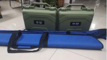
Transport Package
|
Individual Package
|
|
Origin
|
China
|
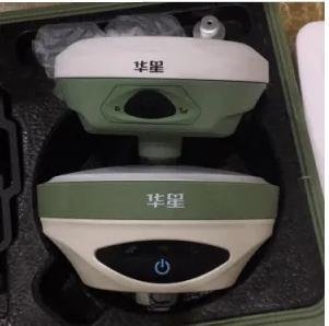
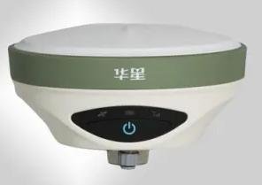
Hi-Target HUAXING A12 GNSS RTK SYSTEM
Huaxing A12 GNSS RTK system is a highly configured product launched by Huaxing brand, and it will inject more scientific and technological achievements on the basis of benefits, with better performance, wider functions and better practicability.
1. New appearance design, magnesium alloy structure, smaller volume, lighter weight;
2. Linux operating system, the function is more powerful;
3. The integrated transceiver station has a more diversified job selection.
4. 8G built-in storage space, can support 32GSD card;
5. Support WiFi and long distance Bluetooth connection
6. A new generation of strong intelligent Android hand book, strong, smart, strong endurance;
7. A new generation of Hi-Survey measurement software, fully meet the needs of the users of various industries, more practical.
8. Support tilt measurement, without accurate alignment, the correct coordinates can be obtained.
9. Electronic bubble technology, complete the intelligent centering.
GNSS Technical parameter
|
System
|
Operating system
|
Linux operating system
|
|
Star time
|
3s
|
|
Data storage
|
build-in 8G memory to support the maximum 32G SD card extension
|
|
GNSS
|
The system kernel
|
the kernel of multi satellite systems
|
|
Channels:
|
220 channels
|
|
BDS
|
B1,B2,B3
|
|
GPS
|
L1C/A,L1C,L2C,L2E,L5
|
|
GLONASS
|
L1C/A,L1P,L2C/A,L2P,L3
|
|
GALILEO
|
GIOVE-A & GIOVE-B,E1,E5A,E5B
|
|
SBAS
|
L1C/A,L5QZSS,
WAAS,MSAS,GAGAN
|
|
Output format
|
ASCII
|
NMEA-0183, binary code
|
|
Location output frequency
|
1Hz~50Hz
|
|
Differential support
|
CMR,RTCM2.X,RTCM3.0,RTCM3.2
|
|
Static format support
|
GNS,Rinex dual format static data
|
|
Accuracy and reliability
|
|
RTK positioning accuracy:
|
Horizontal precision
|
±(8+1×10¯6D)mm ( D for the measured distance)
|
|
Vertical precision:
|
±(15+1×10¯6D)mm ( D for the measured distance)
|
|
Static positioning accuracy
|
Horizontal precision
|
±(2.5+0.5×10¯6D)mm ( D for the measured distance)
|
|
Vertical precision
|
±(5+0.5×10¯6D)mm ( D for the measured distance)
|
|
DGPS positioning accuracy
|
Horizontal precision
|
±0.25m+1ppm
|
|
Vertical precision
|
±0.50m+1ppm
|
|
SBAS positioning accuracy
|
0.5m
|
|
Initialization time
|
< 10 seconds
|
|
Initialization reliability
|
> 99.99%
|
|
Tilt measurement
|
within 30°: ≤ 3cm
|
|
Built-in communication
|
Built-in 4G network communication
|
|
|
TDD-LTE, FDD-LTE, TD-SCDMA, WCDMA, EDGE, GPRS, GSM
|
|
|
WiFi communication
|
802.11b/g access point and client mode, which can provide WiFi hot service
|
|
Bluetooth communication
|
|
Built-in transceiver station:
|
Power
|
1W/2W/5W adjustable frequency: 403MHz-473MHz
|
|
|
Transmission rate
|
19.2kbps/9.6kbps adjustable, frequency channel number: 116 frequency are adjustable
|
|
External radio
|
Power
|
5W/10W/20W/30W adjustable, radio frequency: 450MHz-470MHz
|
|
Transmission rate
|
19.2kbps/9.6kbps adjustable, frequency channel number: 116 frequency are adjustable
|
|
User interface
|
Panel
|
single button
|
|
|
Indicator
|
3 LED lamps: Satellite light, communication lamp, power lamp
|
|
Advanced application
|
IPOWER intelligent balance skill technology, LBS, NFC
|
|
|
Intelligent application
|
speech broadcast, voice guide, function self-examination
|
|
|
Remote service
|
remote upgrade, remote control, remote data downloading
|
|
Electrical and physical characteristics
|
|
Battery
|
high capacity lithium battery 5000mAh, 2 pcs ,can be detachable
|
|
|
Single battery network mobile station can continuously work for more than 10 hours
|
|
|
Input voltage
|
DC 6~28VDC, over - amplifier protection
|
|
|
Size
|
160mm x 76.2mm
|
|
|
Weight
|
≤1.2kg (including battery)
|
|
|
Power consumption
|
4.2W
|
|
|
Material
|
the shell is made of magnesium alloy
|
|
Environmental characteristics
|
|
Dust prevention and release
|
IP68, can resist 2 meters under water temporarily soaking, completely prevent dust entry
|
|
Anti fall
|
3 meters naturally falling
|
|
Relative humidity
|
100% anti condensation
|
|
Working temperature
|
-45 ºC ~75ºC
|
|
Storage temperature
|
-55 ºC~85 ºC
|
|
|
|
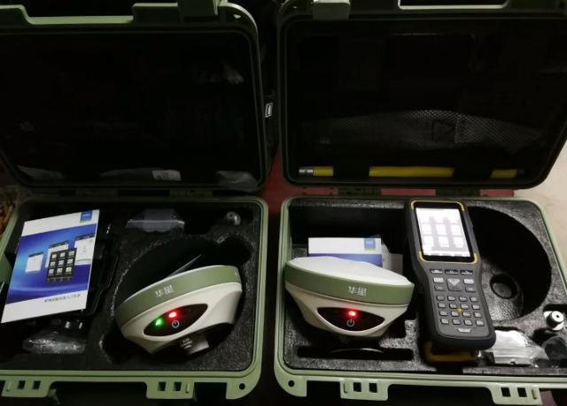
iHand30 intelligent data Collector
|
Operating system
|
Android 6.0 operating system
|
|
Processor
|
1.5G, 4 core processor
|
|
Storage
|
2GB RAM+16GB ROM+128G T-Flash storage card
|
|
Display
|
3.7 inch bright professional outdoor color touch screen
|
|
GNSS
|
Built-in GNSS antenna, support GPS, GLONASS and AGPS, 20 channel
|
|
Communication
|
Built-in Bluetooth (2.1+4.0), USB Type C interface, WIFI and NFC support
|
|
Support 4G all network, double card double stay
|
|
Power
|
Built-in rechargeable 3.7V/5200mAh lithium battery, support quick charge.
|
|
A single battery can continuously work for 15 hours.
|
|
Application
|
Built-in 8 million pixel auto focus camera with high brightness flash led.
|
|
Built-in microphone with voice tagging function.
|
|
Support 3.5mm audio jack
|
|
Gravity sensors, electronic compass, barometer, optical sensor, gyroscope
|
|
Physical property
|
Size
|
208mm x 83mm x 24mm
|
|
Weight
|
440g (containing batteries)
|
|
Working temperature
|
-20 C ~ +55 C
|
|
Storage temperature
|
-30 C ~ +65 C
|
|
Dust proof and waterproof
|
IP67
|
|
Shockproof
|
1.2 meters of free fall
|
Device application
|
>Construction lofting
|
The rich point and line setting function, supplemented by graphical operation guidance, can save more cost for the construction of your project
|
|
>Power traffic
|
Convenient power direction measurement, distance measurement and angle calculation; comprehensive and practical highway survey, middle pile, side pile measurement, longitudinal and cross section measurement function
|
|
>CORS application
|
For the application of CORS system, only one RTK mobile station can receive CORS differential signal for data acquisition, construction layout and so on.
|
|
>CORS station
|
HD-CORS integrated the mature technology of Zhong Haida for many years, and has the advantages of stable operation and long transmission distance. It is the preferred solution for the city continuous reference station system.
|
|
>Control measurement
|
One investment, multiple functions, iRTK dual frequency static measurement accuracy to meet any control survey requirements, supporting mature professional data solver software, can help you complete all kinds of high-precision control survey work.
|
|
>Data acquisition
|
Handbook operation software designed for GIS system, flexible coding function to meet your fast and efficient field data acquisition needs
|
|
> water measurement
|
Equipped with the marine survey, marine mapping software and depth sounder of Haida's surveying and Mapping Authority, the underwater topography survey can be carried out easily, and the traditional operation mode of water survey is completely changed.
|
|
>Construction location (water)
|
The iRTK system helps you to accurately complete the marine engineering, such as riprap, paving and piling, to meet the special requirements of marine engineering.
|
|
|
|
|
| Payment Terms︰ | T/T, Western Union, Money Gram |
|
|
Product Image
|